
Exploring Google Earth can be an entertaining way to kill time. In a world where most of our planet’s landmass has been photographed by satellites, there are opportunity for us to check out some peculiar, fantastical, and sometimes down right creepy things around the world. Most of these entries have interesting scientific explanations, most of them are blamed on the occult, government conspiracies, or on aliens (honestly, aliens get blamed for most of them,) but some of them truly deserve their own episode of The Twilight Zone.
The truth is out there, but so are lies, discover the difference by checking out this list of the best UFO subreddits and Youtube Channels to follow.
1. A Very Strange Ritual
In Mexico City, hidden away at the address of 151 Canada is something you certainly wouldn’t see every day. If you drop down into street view and scroll into the backyard of this specific house, you will find nine people dressed up in what appear to be Lion King onesies and reading from a Lion King children’s book as if it were some holy text.

Perhaps the most worrisome part of the image captured is that they seem to have surrounded our google earth cameraman. Is there away to check on them? Are they still with us? Or are there now ten cultists in that circle?
2. The Missing Car
In August of 2019, Barry Fay received a call from one of his neighbors, informing him that there appeared to be a car submerged in the pond behind his house. The neighbor was using Google Earth to explore his surrounding area and credited it with the discovery. When the heavily calcified vehicle was excavated from the pond, authorities found a human skeleton in the driver’s seat.
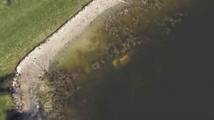
It turned out to be the body of William Moldt, a 40-year-old man who had gone missing 22 years ago. In November of 1997, Moldt had called his girlfriend to let her know he was coming home from the club, only to then never be seen or heard from again. He had evidently driven into this pond while the surrounding housing development was still under construction.
3. Sandy Island
Off the coast of the French Territory New Caledonia, just Northwest of Australia, Sandy Island, or its more sensational name “Phantom Island” was first spotted and mapped out by British explorer James Cook in 1776 and then again in 1895 by a whaling ship. In addition to these two in person sightings it also shows up on Google Earth but as a dark splotch (now just a tan blurry splotch) and stretches nearly fifteen miles long and just over 3 miles wide.
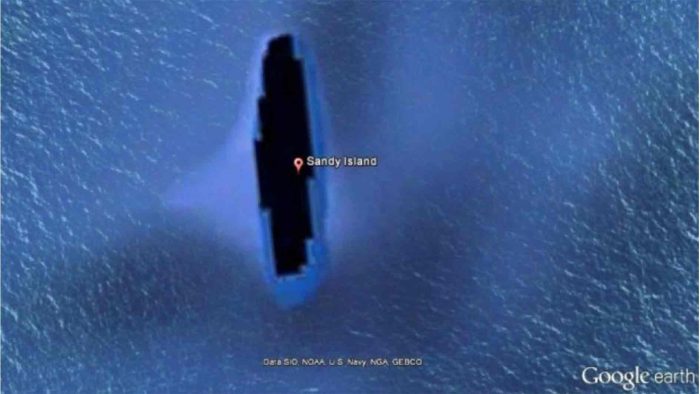
However, in November of 2012, Australian Scientists set out to official explore the island, only to discover there was no such island there. They also recorded the oceans depth in that area and found that the water a whooping 4,620 feet deep. Too deep for anything on the ocean floor to be visible from satellite, much less early 20th century explorers. It still however shows up on satellites.
4. Taal Lake
Taal Lake is a lake located on the Philippine island of Luzon, and its strangeness is one of a more whimsical nature.
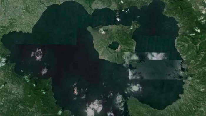
You see, in the middle of Taal Lake there is an island, the Taal Volcano, and inside that island is Crater Lake, and in the middle of Crater Lake there is an island (which is simply marked on Google Earth as “Batangas Scenery” Batangas being the province that Taal Lake resides in.) So what you’ll find if you plug in those coordinates is an island inside of a lake that’s inside of an island inside of a lake that’s inside of an island in the sea. (It’s not 2011 anymore so there isn’t an Inception joke here but just know that there could have been.)
5. Fairy Circles
Fairy Circles can be found in deserts all over the world, speculation as to what causes them have ranged from competition for water among plants, to UFO landings, to folktales of fire-breathing dragons that live underground. However, the real reason for these strange polka-dot patterns, while not as astounding as a dragon, is because of something living underground.

Ants! is the answer, specifically red harvester ants, and a similar phenomenon can be observed in the Namib Desert with termites. What they do is when they build their underground nests, they clear out all the debris and vegetation surrounding each entrance, leaving these large, uniform circles of bare earth that are wide enough to be seen from space.
6. A Sea Monster?
This guy has been sighted trapsing around Ocean Front Walk in Sand Diego, California. Again by dropping into Street view, you will see a man covered in seaweed and doing his best impression of an old school Scooby-Doo villain.

This Creature from the Black Lagoon is first seen taking pictures with onlookers and waving to cyclists as they pass him. Then as the Google Earth camera gets closer, he appears to chase the it for several yards until finally shooting it a thumbs up as it carries on its way.
7. Flying Rabbit
Somewhere in Poland, if you drop into street view and scroll down the Biala Droga, you’ll find this rabbit who might in fact be bio-chemically enhanced.
I can’t think of many other explanations for why this rabbit seems to be able to leap over a car. Nor can I explain why it seems as though he changed directions to appear as if he was leaping from the opposite side of the street from where he started. Perhaps he jumped onto the hood of the Google Earth car as it drove by then jumped from the hood into the air, perhaps rabbits can jump higher than we originally thought, or perhaps this rabbit simply glitched and clipped out of the simulation. But probably the first one.
8. Airplane Graveyard
Dubbed “The Boneyard” by the U.S. Military, the Davis Monthan Air Force Base in Tucson, Arizona is where the Military stores old, out of commission planes so that they may be either stored on a temporary basis or scrapped for parts and left to rust.

While there are many airplane graveyards throughout the world, the Boneyard of Tucson is the largest of them all, and since it is closed to the general public, Google Earth is the best way to view its various heaps of war machines past. Some planes in the Boneyard have been there since World War two, while others are there short term while they wait for military aircraft to increase in market value.
9. Desert Etchings
Found in the Gobi Desert, this .65 mile wide, 1.15 mile long collection of zig-zagging lines was at first thought to be either markings left by a UFO, street map layouts of Washington DC (etched into the desert for some reason), or a secret Chinese weapons testing facility.
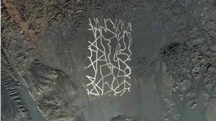
In reality however, this artistic-looking site is actually used to calibrate and orient Chinese satellites. What’s most fascinating about this site, however, is the fact that these large 65 foot wide lines aren’t made of some kind of reflective metal but rather painted onto the desert floor itself with chalk.
10. Giant Pentagram
On an uninhabited peninsula in Kazakhstan, where the closest living human inhabitants are twelve miles away, among ancient ruins, Bronze-age settlements, and sacred burial grounds, there lies a giant pentagram 1,200 feet in diameter.
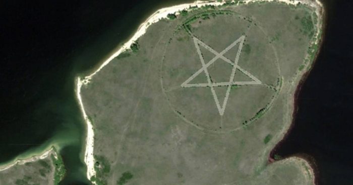
Now for anyone who has played the recent Doom remakes, a giant Pentagram seemingly carved into the surface of the Earth certainly seems alarming. You don’t have to be religious or a Doom fanatic to feel that way. However, this isn’t the result of some Wiccan summoning ritual or a Satanic Comic-Con venue. The real reason for its appearance is not Occult but rather, Nationalist. That Peninsula was at some point meant to be a public park and the Star shape is actually supposed be reminiscent of the U.S.S.R as the Soviet Union is probably the one who attempted to build the park in the first place. It’s still a mystery as to why the park was unfinished and seemingly abandoned. Maybe they accidentally summoned something after all. (Cue Twilight Zone Outro)
Dive deeper into the Occult by checking out the best paranormal podcasts to freak yourself out.


